100% FREE ONLINE DATING
sponsored links
| Topic: GeoPhysical Activity... | |
|---|---|

|
|
|
Could the sub surface 'crust' have developed a crack?
Could Fiji be gearing up to a 'devation' from normal activities? The recent movement there was a deep earthquake to be registering 5.2 at the surface. |
|
|
|
|

|
|
|
I was kinda wondering about that too.. from new Zealand to Japan...there has been lots of activity along that faultline...there was another quake (5.4) yesterday almost in the same spot as the one today near fiji....
|
|
|
|
|

|
|
|
There was "doomsday talk" when they were building the 3 gorges dam in China that when it filled up, "the weight of the water contained would depress the Earth's crust in the region"! Hey just because you're paranoid, doesn't mean they're not out to get you.
Seriously, I haven't been recording or really keeping track, but it seems to me from the news reports, that there is an increase in seismic activity globally over the last 10-15 years. Could be a normal cycle, or just that as I get older I watch more news. Maybe the Mayans were right. |
|
|
|
|
|
|
|
|
There was "doomsday talk" when they were building the 3 gorges dam in China that when it filled up, "the weight of the water contained would depress the Earth's crust in the region"! Hey just because you're paranoid, doesn't mean they're not out to get you. Seriously, I haven't been recording or really keeping track, but it seems to me from the news reports, that there is an increase in seismic activity globally over the last 10-15 years. Could be a normal cycle, or just that as I get older I watch more news. Maybe the Mayans were right. http://hisz.rsoe.hu/alertmap/index2.php |
|
|
|
|
|
|
|
|
I was kinda wondering about that too.. from new Zealand to Japan...there has been lots of activity along that faultline...there was another quake (5.4) yesterday almost in the same spot as the one today near fiji.... Yeah but it was not as deep. 522 miles... That is in the sub-surface crust. |
|
|
|
|
|
|
|
|
There was "doomsday talk" when they were building the 3 gorges dam in China that when it filled up, "the weight of the water contained would depress the Earth's crust in the region"! Hey just because you're paranoid, doesn't mean they're not out to get you. Seriously, I haven't been recording or really keeping track, but it seems to me from the news reports, that there is an increase in seismic activity globally over the last 10-15 years. Could be a normal cycle, or just that as I get older I watch more news. Maybe the Mayans were right. http://hisz.rsoe.hu/alertmap/index2.php Not quite sure I really want to know.  Still trying to convince myself it's normal for the Government to suddenly, with absolutely no public notification, stage 5 days of "Drills" in the Metro NY area. The drills, began last Thursday to "prepare for the prevention and response to a "Dirty Bomb" attack on NY" according to News 12(the local cable news). Not a peep on Network or in the papers. Ignorance is Bliss! Still trying to convince myself it's normal for the Government to suddenly, with absolutely no public notification, stage 5 days of "Drills" in the Metro NY area. The drills, began last Thursday to "prepare for the prevention and response to a "Dirty Bomb" attack on NY" according to News 12(the local cable news). Not a peep on Network or in the papers. Ignorance is Bliss!
|
|
|
|
|
|
|
|
|
I was kinda wondering about that too.. from new Zealand to Japan...there has been lots of activity along that faultline...there was another quake (5.4) yesterday almost in the same spot as the one today near fiji.... Yeah but it was not as deep. 522 miles... That is in the sub-surface crust. according to that website i just posted, they were both about the same depth, but it said 322 and 329 miles deep... i think what you saw was KM, not miles... Notice! This is a computer-generated report - this event has not reviewed by a seismologist! Share: Megosztás Follow RSOE_EDIS on Twitter EDIS Number: EQ-20110410-194705-FJ Common Alerting Protocol Magnitude: 5.4 Mercalli scale: 6 Date-Time [UTC]: 10 April, 2011 at 16:18:20 UTC Local Date/Time: Sunday, April 10, 2011 at 16:18 in the afternoon at epicenter Location: 23° 33.000, 179° 50.400 Depth: 530 km (329.33 miles) Region: Pacific Ocean - East Country: Fiji that was the one yesterday Magnitude: 5.3 Mercalli scale: 5 Date-Time [UTC]: 11 April, 2011 at 02:01:17 UTC Local Date/Time: Monday, April 11, 2011 at 02:01 at night at epicenter Location: 17° 49.200, 178° 13.800 Depth: 519 km (322.49 miles) Region: Pacific Ocean - East Country: Fiji todays... |
|
|
|
|
|
|
|
|
You are right... I transposed miles and km's...

They were both quite deep. They were both on the same 'crustal plate'... and they were close together. Like is asked could the sub-surface crust be 'cracking'? |
|
|
|
|
|
|
|
|
something is wierd, i checked on a bunch of others, and none besides those two was over 100 miles deep... there were 5 today in neveda, but they were all surface quakes...
|
|
|
|
|
|
|
|
|
That is definitely a cool site! Thanks

|
|
|
|
|

|
Edited by
metalwing
on
Sun 04/10/11 10:25 PM
|

The lithosphere is the outer solid part of the earth, including the crust and uppermost mantle. The lithosphere is about 100 km thick, although its thickness is age dependent (older lithosphere is thicker).The lithosphere below the crust is brittle enough at some locations to produce earthquakes by faulting, such as within a subducted oceanic plate. |
|
|
|
|

|
Edited by
Jess642
on
Sun 04/10/11 11:09 PM
|
|
What concerns me is the tsunamis that follow...
it appears the whole pacific plate is flexing....that means the other end of the Pacific Ring of Fire...Hawaii is also vulnerable. We've had earth tremors in places I didn't even know could, in the past month! |
|
|
|
|
|
|
Edited by
mightymoe
on
Sun 04/10/11 11:37 PM
|
|
What concerns me is the tsunamis that follow... it appears the whole pacific plate is flexing....that means the other end of the Pacific Ring of Fire...Hawaii is also vulnerable. We've had earth tremors in places I didn't even know could, in the past month! |
|
|
|
|
|
|
Edited by
AdventureBegins
on
Mon 04/11/11 12:36 PM
|
|
The lithosphere is the outer solid part of the earth, including the crust and uppermost mantle. The lithosphere is about 100 km thick, although its thickness is age dependent (older lithosphere is thicker).The lithosphere below the crust is brittle enough at some locations to produce earthquakes by faulting, such as within a subducted oceanic plate. Nice sensors graphic. That is all it shows. The 'sensor' readings of a human colony that resides upon the earth. In order for the earth to be as old as it is (within) the local stellar fild. It must have formed earily. By catasrophic collision of a small 'Hot' stellar mass with a LARGE minor planetiods... More than likely carring several ice comets picked up over thousands of years. The Earth is made up of the fragements left by that collision. A hot stellar fragment would have gravity. The fragements of the colision would have eventually 'slumped' into that gravity field aided by the fact that it was "HOT'. This planet would not be such calm and perfect layers. Your graph is but a 'slice' of the sphere taken by the 'flash' joining of many readings. If you time join them forward (as you do with the weather - globaly). You would see a far different graph developed. |
|
|
|
|
|
|
|
|
What concerns me is the tsunamis that follow... it appears the whole pacific plate is flexing....that means the other end of the Pacific Ring of Fire...Hawaii is also vulnerable. We've had earth tremors in places I didn't even know could, in the past month! There have been heaps of activity right along the pacific plate down here...Philipines, Indonesia, New Zealnd, Japan....all the way along the edge of the plate....daily.. For me, where I live...the biggest challenge would be a tsunamai...and of course the chances of one like Japan, or Archai years ago, are small, as we have the Barrier reef to protect us...well act as a buffer. |
|
|
|
|
|
|
|
|
The lithosphere is the outer solid part of the earth, including the crust and uppermost mantle. The lithosphere is about 100 km thick, although its thickness is age dependent (older lithosphere is thicker).The lithosphere below the crust is brittle enough at some locations to produce earthquakes by faulting, such as within a subducted oceanic plate. Nice sensors graphic. That is all it shows. The 'sensor' readings of a human colony that resides upon the earth. In order for the earth to be as old as it is (within) the local stellar fild. It must have formed earily. By catasrophic collision of a small 'Hot' stellar mass with a LARGE minor planetiods... More than likely carring several ice comets picked up over thousands of years. The Earth is made up of the fragements left by that collision. A hot stellar fragment would have gravity. The fragements of the colision would have eventually 'slumped' into that gravity field aided by the fact that it was "HOT'. This planet would not be such calm and perfect layers. Your graph is but a 'slice' of the sphere taken by the 'flash' joining of many readings. If you time join them forward (as you do with the weather - globaly). You would see a far different graph developed. I read your post twice and I still don't know what you are talking about. The grafic is just textbook stuff of how the crust sits on the mantle and the approximate thickness of the layers. The "ring of fire" is a subduction zone so the mechanics are somewhat different. 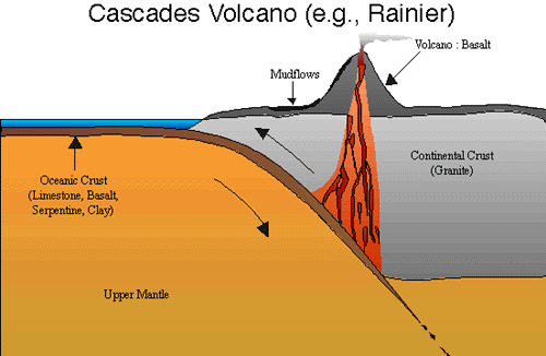
The above would be your typical subduction zone which produces coastal earthquakes. 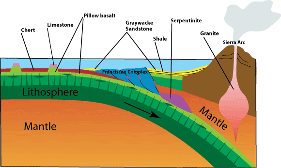
The above is your typical island subduction zone which tends to produces tsunamis from the underwater earthquakes. The faults along the upper coast of the western US are underwater. |
|
|
|
|
|
|
|
|
A 'sensors' graphic.
A false color representation of interpreted data. As above so below. If you have mountains upon the surface you also have 'mountains' in the mantel... the material of those mountains may differ... but they exist. The mantel is not a smooth continus mass. The mantel of the Earth is several very large masses held together by gravitational forces and 'heat'. Your charts are no more than a training tool. They are not based on reality but rather an interpretation of percevieved reality using 2d Data. the earth is a spherical entity comprised of several smaller masses. |
|
|
|
|
|
|
|
|
A 'sensors' graphic. A false color representation of interpreted data. As above so below. If you have mountains upon the surface you also have 'mountains' in the mantel... the material of those mountains may differ... but they exist. The mantel is not a smooth continus mass. The mantel of the Earth is several very large masses held together by gravitational forces and 'heat'. Your charts are no more than a training tool. They are not based on reality but rather an interpretation of percevieved reality using 2d Data. the earth is a spherical entity comprised of several smaller masses. I am not sure what your point is. I only provided them as a training tool... specifically to show how the quakes could exist over 100km beneath the surface near a subduction zone and to give anyone interested in the conversation a visual of what is being discussed, why some earthquakes cause tsunamis and some don't, and why there are volcanoes nearby. The mantle is a semi-liquid mass moving with currents and eddies floating over a liquid iron core. It isn't held together by heat but you seem to be placing heat in some new category. 
|
|
|
|
|
|
|
Edited by
AdventureBegins
on
Wed 04/13/11 03:07 PM
|
|
Very nice representation...
Based on sound frequences translated to the visable spectrum. a simply 'sensors' display. It shows not what is, only what we can 'see' by sound. (not to mention it is a 2d representative 'slice' of a spherical object). |
|
|
|
|
|
|
|
|
another deep one near fiji
20110419-195675-FJ Common Alerting Protocol Magnitude: 5.1 Mercalli scale: 5 Date-Time [UTC]: 19 April, 2011 at 15:30:10 UTC Local Date/Time: Tuesday, April 19, 2011 at 15:30 in the afternoon at epicenter Location: 19° 55.200, 177° 39.600 Depth: 400 km (248.55 miles) Region: Pacific Ocean - East Country: Fiji Distances: 60.74 km (37.74 miles) of Vatoa, Source: EMSC |
|
|
|
|